Bike to Climb - Mount Waddington
- Langdon
- Aug 21, 2024
- 22 min read

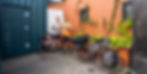
Photo by Ben Speirs
This was an attempt by Ben and I to climb Mount Waddington, in the Coast Range of British Columbia, Human Powered. We ended up taking several ferries along the way home, so while not completely human powered, this was one hell of an adventure. The entire route took us over 5 weeks so this is quite a lengthy post. Put on a pot of coffee, or read in sections. Hopefully this layout works well to keep things organized.
Ellensburg - Bellingham
Day 1 - June 25
With last minute bike repairs completed, Ben and I departed Ellensburg mid-morning, on bicycles.

We took the Palouse to Cascades trail, but opted for pavement whenever the option was presented.

In our training rides we learned that the difference in speed between pavement and gravel really stacks up on long days. 50 miles of gradual uphill riding brought us to the 2-mile-long Snoqualmie tunnel.

Then a long downhill into North Bend. From here we headed north along Hwy 202 and 203 through Carnation. Approaching sunset, we found a nice, albeit buggy spot along the Snoqualmie River to get some rest.

Day 2 – June 26
We biked into Duvall and sat down for a nice cup of coffee before heading North. Once into Snohomish, we enjoyed car-free biking along the Centennial Trail. Just after passing through Burlington, afternoon showers settled in for the rest of the day.

We arrived wet and cold in Bellingham, but thanks to Jamie, we had a cozy apartment to get out of the weather and plan our next steps, or pedals.
Day 3 - June 27
It was here that we ran into a huge logistical problem. To avoid carrying all of our climbing gear on our bikes, Ben and I had shipped three packages to the small town of Tatla Lake, BC. This is the closest post office to Mount Waddington, just 30 miles from were we would leave our bikes and start on foot. As it turns out however, mailing goods across international borders does not always go smoothly. One of our packages had made its way to Toronto and promptly gotten stuck indefinitely in customs. It was becoming clear that even if the package were to be released from customs, there was almost no chance of it showing up in time to Tatla Lake. The lost package contained almost all of my climbing gear ( a double rack of cams, many slings and draws, pitons, climbing shoes, harness, mountaineering boots, ice tools, crampons, webbing, a trekking pole, a bivy sack, pickets, a probe, and probably some other stuff). Upon realizing we had a serious problem, I sent out a series of frantic text messages and phone calls to friends in Ellensburg and Canada, looking for gear to borrow and trying to figure out how to get a hold of it. My mom came to the rescue and gathered up some leftover gear of mine and Ben's, as well as some borrowed gear from friends in Ellensburg and met us in Bellingham. My sister also happened to be in Bellingham at the time, so we had a nice family dinner and my mom was able to drive my sister to the airport on her way back home. Not a total waste.
Ben and I now had almost everything we needed, we just had to carry it on the bikes. And the logistical nightmare had only set us back a day.
Bellingham - Williams Lake
Day 4 - June 28
With rested legs, we left Bellingham, eager to start our Canadian vacation. We crossed the border at Sumas, no questions asked. We made our way to the nice town of Chilliwack where we purchased a few days worth of food at my new favorite grocery store: save-on foods. We then stopped at Mt. Waddington's outdoor, the local gear shack, to replace the last of the gear that was lost in the mail. The folks at Mt Waddington's were extremely helpful and sent us on our way with some shiny new gear and their best wishes for our trip!
Oh how innocent we were, thinking we were headed out on a fun little adventure...

Once out of town, we intersected Hwy 7 and started riding North towards Hope. Daylight was waning, so we opted to engage in a stealth camping operation. We found a nice spot atop a levy splitting two farm fields. There was just enough shrubbery for some cover. No cover from the mosquitoes however.
Day 5 - June 29

I enjoyed some of the pie I had purchased at the save-on as a pre-breakfast snack. After riding a short ways and merging with Hwy 1, we stopped at the Somewhere Else Cafe for a good old fashioned breakfast. This would start our tradition of trying out as many breakfast spots as we could along the trip. I quite liked this spot. Good food and hot coffee.
We continued north on the Trans-Canadian Highway, following the Fraser River until we got to Lytton. This town burned down 3 years ago after hitting record breaking temps of nearly 50 degrees Celsius. We rode into town hoping to find a store to fill water only to find the town still flattened. Nothing had been rebuilt since the fire.
From here we continued up 1, but now along the Thompson River. Just shy of Spences Bridge, we made camp at a nice sandy beach along the river, accompanied by trains every hour or so.


Day 6 - June 30
Another lovely breakfast spot, this time at The Packing House in Spences Bridge.

North of Spences Bridge along the Thompson River

At Cache Creek, Hwy 1 intersects Hwy 97. We happily departed the Trans-Canadian Highway, but traffic wasn't really any better along 97. Afternoon squalls were refreshing and we made steady progress Northward. We had dinner in Clinton, then continued riding until dark. Soaked, cold, and being chased by mosquitoes, we decided a motel room was in store.

Day 7 - July 1
A beautiful morning of riding as the sun came out and dried out the roads. We were now out of the desert and into the higher country of endless lakes and trees.


Of course we got breakfast. We pulled of in 100-mile house and found the Chartreuse Moose, home to freshly roasted coffee and splendid breakfast. We were properly fueled for the day ahead. The riding through this section was very enjoyable. Rolling wooded terrain with many lakes.
The day went fast and we were soon rolling down the banks of Williams lake into the "big city". Turns out it was rodeo weekend in town, so our original plan of camping in the rodeo grounds wasn't going to work, at least if we wanted to get any rest.
We got a motel room, and then got to work shopping for the next 20 days. Williams lake is the only town in the area with real grocery stores and access to gear. We bought 19 days worth of food as well as all of the stove gas we would need. Back in the hotel room we struggled to pack it all on our bikes.

Williams Lake - Foster Ranch
Day 8 - July 2
After a chaotic morning of packing and bike repairs, it was time to ride some big hills with way too much weight. Headed West out of Williams Lake, you do a short uphill, before dropping 1,600 ft down to the Fraser River, then climbing 1,700 ft up the other side.


I didn't know speed wobbles were possible on a bike, but they certainly are. I couldn't figure out why it felt like my bike was wagging its tail until I realized that under all the food weight, the frame was bending laterally, oscillating back and forth. Luckily this was only at certain speeds and partially avoidable with more delicate pedaling.

Once up the other side, we were officially in the Chilcotin! It really felt like we were getting out in the boonies now. The high country of Lodgepole pine, lakes, and bugs. The highway traversed rolling hills as it meandered towards the Chilcotin River.


Just before dark, we passed through Alexis creek and shortly thereafter found camp along the Chilcotin River. A lovely spot indeed.
Day 9 - July 3
Today was a Wednesday, which meant that the post office in Tatla lake was open from 9-3. We needed to boogie to make it to town before they closed, otherwise, we would have to wait until Friday.
We were riding just before 5:00 am. The landscape here is beautiful and expansive. A high plateau of rolling hills, draped in forests of lodgepole, aspen, and the occasional spruce.

We arrived in Tatla Lake at 1:30 pm. We settled into our room at the Graham Inn, then walked over to the West Chilcotin Trading Company - A general store that serves as a basic post office. Two out of our three packages were waiting for us! I also picked up some fresh berries, meat, and cheese to snack on before dinner.


The gear sprawl. 18 days worth of food plus all of the gear I had to fit onto my bike and then into my backpack. Ben had is own pile.
Day 10 - July 4
I got to sleep nearly 12 hours last night. We slept in and were treated to an amazingly huge breakfast at the Inn.

We slowly loaded our bikes and rolled out in the early afternoon. 30 miles of beautiful riding through the countryside brought us to the Foster family ranch, on the edge of the Coast Range. We met Walt and Carol, and they kindly pointed us towards a pasture along Mosley Creek. They told us to camp wherever we pleased and to leave our bikes wherever. The worst that could happen is that a bear might try to sit on them!


Our lovely camp in the pasture. Ben and I were psyched. We were stoked to have completed the first phase of the trip. Tomorrow we would get to rest our behinds and enjoy some travel on foot. Little did we know we were about to embark on the most miserable foot travel known to man...
Twist Creek
Day 11 - July 5
It took us all of a couple minutes to realize we were in for at-least somewhat of a suffer fest. As we tried to heave our backpacks onto our shoulders, it became apparent that we had a lot of weight. We needed each-others help to get our packs on our backs. I estimate that we were each carrying around 100 lbs to start. An absurd amount of weight, and even more absurd given there was no trail, thousands of downed trees, and 13 miles of thick brush between us and where we would pop out above treeline.

Ben with his insanely huge pack.
While quite grueling, the first day on foot went pretty well in retrospect. We made it 7 miles to a nice camp next to Vishnu Creek. Overall, travel was fairly easy with most of the forest having been burned last summer. Little brush, just some dead-fall to navigate. The difficulty was our pack weight. Going into this, I figured our packs would be heavy and we would move slow, but I figured we could do long days and still make good time. It turns out, unless you are a superhuman, its nearly impossible to carry a 100lb load on your back for more than 10-12 hours in a day. You just kind-of collapse at some point. In my journal I wrote "quite possibly the hardest physical day I have experienced." Things were about to get a lot worse.


Our camp along the creek.
Day 12 - July 6
"The day from hell"

Me trying to load my pack by myself.
Today started similarly to yesterday. Open terrain with lots of dead-fall. Things went downhill quickly. About a mile from camp, Ben realized that he had forgotten his sunglasses. I gave him my phone with a GPS marker for our current location and last nights camp. He went to retrieve his glasses while I got a break to catch up with my journal.

Moving forward, our progress slowed. Instead of 400-800m between breaks to give our beaks a break, we were only able to make it 200-300m. The burn zone faded, and we found ourselves slogging through thickets of slide alder, vine maple, devils club; all with no views or signs of progress. And the mosquitoes taunted us the whole way.


This grueling misery of this day is hard to convey, and unfortunately, we were too wasted and pissed off to take many photos. There were many slips, falls, grunts, and cursing. Every log crossing and footing slip require a bout of maximal exertion to avoid falling over.
At some point around 5:00 pm Ben collapsed in a pile of ash, curled up beneath a rock. With no water, we were forced to find somewhere else to camp. I left Ben under the rock, and carried my pack forwards, towards twist creek, looking for any possible place to pitch the tent with water nearby. After about an hour of heinous bushwhacking through continuous alder and devils club, I found a patch of burnt roots just above the creek. I dropped my pack and made my way back to Ben. It was far easier to thrash through the devil's club than any other way, so I took a kind liking to a plant that few others appreciate.
When I reached Ben, he was still in the same spot and same position - curled up under the large rock, covered in soot and ash. I hoisted his pack onto my back and he followed me to our camp for the night: the most hellish place I have ever slept. We arrived as it was getting dark. In over 12 hours, we had made just 3 miles of progress.
Day 13 - July 7
Another grueling day. We started bushwhacking at 9 and made slow progress through similar terrain. Tons of downed trees and tons of thick brush. 3 hours later, we had made it 1 mile to the forks. A milestone that gave us some hope. After a very sketchy and careful crossing of Twist Creek, we headed up the SW fork.


As we made slow uphill progress, travel conditions slowly improved. Intermittent game trails provided a nice reprieve from the shwhack. Just before sunset, we popped out of the alder and onto a talus field. I don't think I have been happier to see open terrain.

Just 3 miles from where we woke, we made camp at treeline, ecstatic to be out of the brush, at-least for a while! We were so overjoyed, we decided to sleep out, sure that the mosquitoes would die off in the night. In fact they didn't and we got one of the worst nights of sleep the entire trip. At 1 in the morning I set up the tent. An hour later, Ben crawled in. The mosquitoes never sleep up here.

Granite Pass - Scimitar Glacier
Day 14 - July 8
I woke up excited for the day ahead, for the first time since the ranch. There would be no bushwhacking today!
We made our may to the head of the valley, then up towards Granite Pass. A good bit of elevation, but our high spirits made it feel easy.


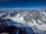
Once at Granite Pass, we enjoyed spectacular views down the twist creek drainage to the North and into the heart of the Waddington Range to our south. We were finally in the mountains and it felt so good. This is what we had come here for. An expansive landscape of rugged mountains, capped with spectacular glaciers.


We made our way across a small glacier, then headed down to Bifrost pass. We arrived in the afternoon, but decided to relax and settle into camp early. In an effort to lighten our packs, we left a food cache for our way out (two days of food and a half-empty fuel canister).

At sunset, we enjoyed spectacular views of the range. Our spirits were soaring!

The Waddington range: Tiedemann center, then Combatant, then Waddington at the right.
Day 15 - July 9
Today started out great, but finished in a complete disaster.
From Bifrost pass, we descended to the bottom of the Oval Glacier. Beautiful heather meadows and spectacular granite boulders.


These boulders are actually sitting on top of a glacier. Ice underneath is covered in feet of debris. We didn't realize this until reaching the end of the ice and seeing the exposed wall.
As we descended to Oval Lake, we made our may back into the bush. This is the view from the last talus, looking into the bushwhack to come. The high moraines of the Scimitar glacier visible ahead.


Back into the thick of it. You know the story by now.

Upon reaching the end of the bushwhack, I realized that my helmet was missing from my pack. I had used a helmet net to attach it to my pack. Somewhere in the last 3 hours of bush, it had been ripped off my back. I spent an hour trying to retrace my steps, but it was hopeless.
Ben and I discussed what the implications were, but soon Ben was overwhelmed by thinking about the remoteness of our location and the innate dangers of the mountains ahead. I think he wondered what the hell he was doing in a place like this, and the helmet loss was the perfect trigger to bring these feelings out. A complete mental breakdown ensued, fueled by complete exhaustion and a justified fear for the mountains we were in.
I used my sat phone to contact my climbing mentor and friend Jeff. His advice, at-least for the helmet problem, was continue until it felt unsafe. No point in bailing based on potential future safety concerns. I think this was the best advice he could have given.
We pitched the tent of a flat boulder and I went to sleep thinking we would turn around in the morning. Enough stress and exhaustion breaks down the body and mind...but sleep is an amazing remedy.
Scimitar Glacier - Combatant Col
Day 16 - July 10
We woke with much better spirits. We packed up camp and scrambled down to the bottoms of the Scimitar Glacier. A tongue of ice, 1km wide, covered in a thick layer of debris from the eroding mountains. The scale of this place is hard to comprehend. The Scimitar glacier's terminus is at just over 3,000 ft. The head of the glacier is nearly 12 miles up valley and at nearly 10,000 ft. At its widest, it is well over a mile wide. The scimitar is dwarfed in size by the Franklin Glacier to the south.

Our route onto the Scimitar Glacier

We spent the day walking up the valley glacier, marveling at the views and the scale of the mountains. The drama from last night was behind us!

Looking up the Chaos Glacier

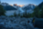
Just before the base of the Scimitar ice fall, we left the glacier and gained a rocky ridge. We found a nice heather ledge to pitch the tent. We even had running water just around the corner. This ended up being my favorite camp of the trip. A spectacular site in an improbable setting.


Day 17 - July 11
"Never have I ever crawled up a glacier"
We were up at 6, but this turned out to be way too late. We worked our way up the ridge until reaching the Northern lobe of the Scimitar Glacier.

We roped up, then continued upwards, picking a narrow line between the outrun zones of seracs above. In full sun now, the snow was very soft. I was post-holing to my waist and progress was minimal. It proved easier to try and crawl on all fours. Eventually we made it above the seracs and onto the final snow slopes below the col. Firmer snow sped our progress.

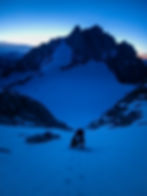
Once at the Waddington-Combatant Col, it was time to set up our base camp. Before anything else, we probed out a perimeter to ensure we weren't setting up camp on top of a crevasse. Then, the first order of business was to dig out and compact a flat platform for the tent. After the tent was pitched, I cut blocks of snow with a shovel and erected a snow wall to protect us from the wind. If a storm were to blow in off the ocean, wind speeds would likely 80-100mph+. Luckily we experienced no such weather, but we wanted to be prepared.

After we completed the essentials, we carved out some benches and enjoyed our spectacular spot. Not many people get the opportunity to sleep in this place, and far fewer enjoy the satisfaction of completing the grueling approach on foot. Most people who climb in the range fly in with Mike King who operates White Saddle Air. We rode past his service 8 days ago.

We now felt that we had been successful. The hard part was over and we had persevered. Any further progress was now up to the mountain.

Mount Waddington
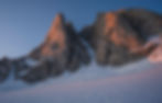
Combatant Mountain
Day 18 - July 12
We spent the entire day resting, eating, and observing the mountain. Our top route choice based on our research was the Kiwi route. It is the most direct route from the Col to the summit tower. While at the Col we witnessed unrelenting ice and rock fall onto the bottom of the route, even through the night. We looked for other safer options. The lower Angle Glacier was fairly broken up and the overhead serac hazard wasn't inspiring. We noticed however that nothing was coming down the Angel Couloir and the seracs above were fairly rounded. In fact there was a break in the seracs right at the top of the couloir. This seemed like our safest option to try and gain the upper mountain.
With clear skies and a good forecast we packed our gear for a summit push. We packed 2 liters of water, food, a stove, 1 sleeping bag, and 1 bivy sack, along with our technical climbing gear. We went to sleep in the evening and I set my alarm for 10:30pm.
Summit Push
Day 19 - July 13
10:30pm wake-up. I had a Larabar and Nutrigrain for "breakfast". Ben and I harnessed up, rigged the ropes for glacier travel and set out across the col towards the mountain. The last of the dusk light was still on the horizon. Soon we were to the bergschrund, which we needed to cross to gain access to the Angel Couloir. Ben walked up and down its lower border searching for the best place to cross. Nothing looked good. The crack was way larger than we anticipated. Most places it was easily big enough to fit a school bus. Eventually, we found a section that had partially collapsed. We were able to walk into the schrund, but a wall of steep ice and overhanging snow above looked nearly impossible. Ben led a pitch of ice up to the snow above but was unable to climb the soft overhanging snow above. He down-climbed and we searched for other options. We eventually noticed a cave in the ice that extended back and upwards. As a last ditch effort, Ben led a short pitch of ice to the cave opening, then climbed into the cavity. A sort of ice chimney feature followed allowing upward progress. At some point he exclaimed " I can see stars" There was a small hole in the top of the cave, above which was the snowfield we hoped to get onto. He led up to the hole, then slowly burrowed his way through, widening the gap to fit through. On the snow above, he built an anchor and belayed me up. This whole process took 3 or 4 hours, but we had found a way through.

Ben peering into the entrance of the cave
Once in the couloir we enjoyed easy climbing up steep snow and ice.

working our way up the couloir at dawn

A thousand feet upwards and we reached the top of the Angel Couloir. A simul pitch of low-angle ice and we gained the upper Angel Glacier!

We ascended the Angel Glacier to just shy of the Northwest summit.

A short and easy down-climb brought us to "the stroll" The final glacier section that would bring us to the base of the summit tower.

We got extremely lucky with conditions for the summit tower. With over a week of hot sunny weather, a lot of the infamous ice and rime had melted off. Most of the climb was exposed rock. From the notch, we simul climbed to the summit. Some ice remained in the chimney, but it was easy enough to climb around. The final stretch to the summit was still snow and ice covered, but quite soft. We made it to the summit around 4:30 PM. What a view. We were on top of the world! At least the Canadian world.


some gummy snacks from my sister, Abby!

The Franklin Glacier

The Tiedemann Glacier
A view of the Col
Our descent off the summit involved a few rappels and a good amount of down-climbing. We got the rope stuck once, which lost us enough time to avoid rappelling where we could.
We neared the top of the Angel Couloir at sunset. Nearly 24 hours after leaving camp.

With dwindling light we opted to rap the ice section between the seracs.

We descended the couloir with a mix of raps and down-climbing. One final rap got us almost over the bergschrund. We came up a bit short and had to down-climb a short section of ice. Not a big deal, but a bit annoying.

After crossing the schrund, we began the final stumble back to camp. I led the way trying to follow our path from before. Ben followed, unable to walk in a straight line and barely staying upright. We returned to our camp around 4:00 am, 29 hours after leaving. What a climb!
Day 20 - July 14

We spent the entirety of the next day sleeping and eating. We had plenty of food and I thought about whether we should attempt another climb, maybe Skywalk? The cumulative exhaustion of the approach, plus the climb was getting to us though. We physically exhausted, but maybe even more importantly mentally drained. We decided we would celebrate our successful summit, and start on our way back towards civilization tomorrow.
Exit
I'm going to go through the exit much more quickly than the approach. It was much faster on the way out. 4 days compared to 7. Our packs were lighter and it is net downhill. We were also psyched to get home!
Day 21 - July 15
We descended the length of the Scimitar Glacier from the Col to nearly its terminus. We found a great camp in the lateral moraine and somehow it was not filled with mosquitoes.

Day 22 - July 16
Bushwhacked back up pocket valley towards Bifrost Pass. I was hoping that maybe I would find my helmet, but no such luck. We camped at Granite Pass, our last night in the alpine. This section is extremely buggy.


My feet had felt better.
Day 23 - July 17
Descended from Granite Pass into the upper Twist Creek valley. Crossed the creek on the same log, then slogged through the brush all the way back to our campsite from the very first night. While still challenging, this was way easier than on the way up. Our packs were so much lighter and going downhill through the brush makes a big difference.


Day 24 - July 18
The final day on foot. And perhaps the thickest mosquitoes - my god they were horrible. But it was good motivation to get the hell out of here. We made the 7 miles back to the ranch in the morning. Upon returning, we took a set of self portraits to look back on. Pretty funny.


Back at the ranch, Walt and Carol were pleased to see we had made it out alive. I think our appearance made them feel bad for us as they provided us with a delicious lunch! We were so grateful to have some fresh food after so long! After our visit with the Fosters, we rode back into Tatla Lake, and checked into the Graham Inn, my favorite motel in the world.

Day 25 - July 19
We spent the day lounging at the Inn. I called family and friends to notify them that I was indeed still alive and well. We ate a copious amount of food enjoyed the relaxation.
The rear shifter cable housing on my bike had ruptured, so I attempted to fix it, but with no luck. I guess I'll have to make it to Bella Coola or further with no rear shifting. Oh well.
Tatla Lake - Bella Coola
Day 26 - July 20
No pictures from today, but I will write a little. I absolutely love this country. Its like being in a time capsule out here. Tatla lake got their first ever cell tower this year which seems crazy. The folks out here are the nicest I've met. Countless times, people would stop in the middle of the road, asking if we were okay or if we needed anything. These instances really helped fuel us on our way home! We rode west from Tatla Lake on Highway 20. At Anaheim Lake, the highway turns to dirt. From here it climbs to nearly 5,000 ft on the plateau. We camped on the side of the road just before the big hill down into the Bella Coola valley.
Day 27 - July 21
Ravenous mosquitoes had us out of camp bright and early. We stopped briefly at the top of "the hill", then flew down the steep grade into the valley. The dirt highway reaches grades of up to 14% here. Quite a wild road that serves as the main access point for supplies into Bella Coola.

Once in the Valley, we enjoyed the winding road and smooth pavement. We got a spot at a campground in Hagensborg, just 10 miles from Bella Coola. They even had showers for a couple extra bucks.

Day 28 - July 22
Today was a layover day as the ferry runs every other day.
We rode into Bella Coola, bought some groceries, and packaged up all of our climbing gear to mail back home. We were eager to lighten our bikes and pick up the pace. Hopefully this time nothing gets lost in the mail.
I stopped by the hardware store and was able to restore full shifting capabilities to my bike. Surprisingly, Bella Coola has a great Indian restaurant. We enjoyed a nice supper there before returning to our campsite.
Day 29 - July 23
Boarded the Ferry in the morning and we were on our way to Port Hardy. The boat ride was rainy and choppy so we mostly stayed inside, eating and sleeping.


Once in Port Hardy, we pedaled to Port McNeil before finding a nice camp at dark.
Port Hardy - Sidney
Day 30 - July 24
Port McNeil to Campbell River
This was a long day filled with lots of beautiful riding. We made good time in the morning, and stopped in Woss for a late breakfast. The man working made me a fantastic milkshake, though he did have to leave for a few minutes to go and buy the ice cream.
We continued riding, sticking to Hwy 19 to save time. We arrived in Campbell River right around dinner time. While sitting in a Vietnamese restaurant, I messaged someone from the warm showers app and was lucky enough to stumble across a wonderful host. Amelia was kind enough to offer us her guest room in her apartment. We had a hot shower and slept soundly. If you are reading this Amelia, thank you!

Day 31 - July 25
Campbell River to Nanaimo
We woke well rested and continued our journey south. We followed 19A for a break from heavy traffic. In Courtenay, we made a quick stop at a gear store, and I finally had my noggin protected once again. We continued with few stops and made it to Nanaimo in time for dinner.
And we had found ourselves another terrific host. We met Ali downtown at a brewery. The three of us biked back to her house and she set us up with a guest room, pull out couch, shower, and fresh coffee for the morning. It turns out that she had worked on the team that installed the camera at the plumber hut which we had looked at extensively when planning the trip. What a crazy coincidence. Another night of fantastic sleep!
Day 32 - July 26
Nanaimo to Sidney
We ate breakfast in Nanaimo, then headed south to Mill Bay. In Ladysmith we stopped at the Old Town Bakery to refuel. This seems to be THE spot for baked goods! We showed up just in time to take the small ferry from Mill Bay to Brentwood Bay, then biked up to Sidney where my aunt and uncle live. It was a treat to see some of my family after a long and difficult trip.
Day 33 - July 27
Spent the day sharing photos, picking berries, and hanging out with family. A truly restful day preparing us for the final stretch home! And we were treated to home cooked meals and unlimited snacks and baked goods!
Sidney - Ellensburg
Day 34 - July 28
We spent the majority of the day in Sidney, they headed out in the afternoon. We biked south to Victoria where we ate the the Spaghetti Factory, before catching the last ferry to Port Angeles.

Day 35 - July 29
Another very long day. We had a filling breakfast of eggs benedict at the Oak Table Cafe in Sequim. We biked almost nonstop to Bainbridge Island where we caught the ferry to downtown Seattle. Then it was West to North Bend where we found another stellar host. This time we were put up in a cozy tree house, much thanks to Del!
Day 36 - July 30.
Pedaled from North Bend back to Ellensburg. A quick detour just west of Snoqualmie Pass allowed me to say a quick hello to my mom out at her field study site. Then it was all downhill back to Ellensburg.
Home Sweet Home!
What a crazy trip. I still can't believe that we made it happen. This is one of those trips I will never forget. Thanks to all who helped make this happen. There are a lot of you!